Tuesday 27 August 2013

Urbanisation

Urbanisation 
Migration is the movement of people from one place to another (BBC, 2013) so what is urbanisation?

The term 'urbanisation' refers to the growth of an urban area which results in an increase in the percentage of the population living in towns or cities. There are two main reasons urbanisation occurs, these are called PUSH and PULL factors.


Push Factors (of rural area's) 
- Advancement of mechanical goods within agriculture means there is less demand for manual labour (farming).
- Lack of higher education
- Travelling distance - Long distance to hospitals, police, shops and work
- Poor infrastructure - Running water, reliable electricity and road surfaces.
People running from old thatched housing to 'shiny urban world'

Pull Factors (of urban areas) 
- Leisure services (restaurants, shopping centres & nightclubs)
- Universities, colleges and hospitals
- Wide range of job opportunities
with higher wages


Activity:  Using the picture found in the link below, students should list as many push and pull factors they can think of. To differentiate higher ability students should seperate factors on whether they PUSH from rural to urban or urban to rural. Can students already draw ideas about counter-urbanisation? This would provide link to following lesson on counter-urbanisation.

Worksheet link: https://encrypted-tbn1.gstatic.com/images?q=tbn:ANd9GcQhmUAawdArkkvQqjM8QYU_16DNnKSqxlla08HDr66udc8QZc4s8A

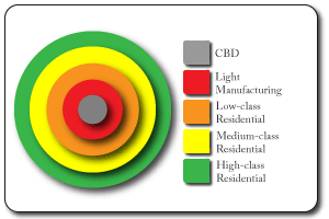
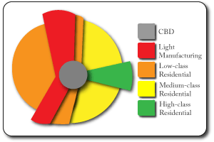
Activity: Using the graph linked below, students should answer the following questions:
- Describe the graph in detail using the key.
- Can you identify which is the most urbanised?
- Is urbanisation increasing, decreasing or staying the same
- Which one has the highest rate of urbanisation?

Higher ability students should start to think of reasons why the figures differ from one another.

Monday 26 August 2013

Urban Models in LEDC's

Urban Models in LEDC's 

Even though land use in LEDC's is similar to that of an MEDC, the pattern of land use is different.


Above is model of an LEDC, when studied you can see the poorest housing lies on the edge of the city (in an MEDC this is the high-class residential zone) and the high-cost housing encircles the CBD. The poorest areas in an LEDC are called shanty towns. Draw particular focus to Rio De Janeiro and Sao Paulo, Brazil where shanty towns are called favelas. Favelas are squatter settlements made from anything the settlers could find, conditions are very cramped and hygiene is poor (no sewerage system, lack of health care or money to provide healthcare). Even though conditions are poor, the community that live in the favelas refer to it as a 'family'.

Watch these videos about shanty towns in Brazil
http://www.youtube.com/watch?v=mS_PjwaqZYE
http://www.youtube.com/watch?v=A8HYuiuxt90
http://www.youtube.com/watch?v=kGXjNCGiEVw
http://www.youtube.com/watch?v=_zMAWztZ6TI


Activity: Over several lessons ask students to prepare a small piece of work on an LEDC of their choice. They must :

  • Give brief introduction to LEDC, name, location, map. 
  • Does the particular shanty town have a name? e.g. Rocinha, Brazil. 
  • Intro into both models
  • recreate a Hoyt Zone Model that fits with their chosen LEDC.

Draw attention to :

  • distribution of land use and cost
  •  distribution of facilities 


Concentric and Hoyt Sector Models


Concentric Zone Model/ Burgess Model

  •  Based on the city of Chicago (an MEDC) 
  • Based on the idea that land value is the highest in the center of a city (competition for space)
  • Designed in 1924 by Ernest Burgess
  • Shows the distribution of social groups within urban areas
  •  The focus of the model is the Central Business District (CBD) and the zones that spread outward from it.


Criticisms:
  • It assumes land and resources are equal in all directions, resulting in the concentric rings. In reality this is not the case.  
  • An advancement in transportation and information technology has meant the zones are no longer clear. People have now chosen to live and work outside the city center. 
  • There is NO such thing as a typical city
perhaps....?

Perhaps the Hoyt Sector Model is more realistic 

  • This model was based on the concentric ring model but took into account the effect of transport routes, this is because industry often chooses specific transport routes (to bring in raw materials or export the finished goods)
  • The low class residential sector is a lot more spread out and closely linked to the manufacturing zone. This is because lower paid workers cannot afford to live in the high-class residential zone so they live in the cheaper sectors (more noise and higher pollution). 

ACTIVITY: Here students could given worksheets which label the sectors, students could start by describing sectors, comparing the Hoyt and Burgess model and brainstorm ideas about the size and distribution of the sectors in the Hoyt Sector Model. For example: I think the CBD has shifted to the right because when the city was expanding it started to move towards the countryside due to a lack of space in the other direction. The original CBD may have deteriorated over time.

Zones 

Central Business District (CBD)
The CBD is located in the middle of a city/town because it is a central location for transport links to converge, it is easily accessible for workers, shops and businesses. Land use of a CBD is as follows

  • Leisure and recreation - parks, sports centres, spa's
  • Residential - houses and flats
  • Transport - railway, road, airports
  • Business and Commerce - offices, shops and banks
  • Industry - factories, warehouses and production centres
Identifying the CBD
  • Mulltistory buildings
  • Expensive land
  • Department stores
  • Shopping centres and pedestrian areas
  • Museums and historical buildings
  • Offices, finance and banks
  • Transport centres

Inner City (light-manufacturing & low class residential) 

Sometimes known as 'the twilight zone', it is typically found next to the CBD.

  • Terraced housing is popular and these were build to house the factory workers who worked nearby, these factories have since shut down but the terraced 'grid' remains.  
  • Many inner cities declined due to unemployment and other socioeconomic factors e.g. St. Anns in Nottingham. 
  • Many of these areas have resulted in gentrification, which refers to the a recent regeneration of the area, making them appeal to young professionals wanting to live near the CBD


The Suburbs ( middle-class residential)

Outside the CBD and the 'twilight zone' is the suburbs, land values are slightly lower due to distance from the CBD; demand for space is decreased and so house sizes increase, many with a garden however due to the desirability of the houses, some areas can be very expensive.


  • Homes are either detached or semi-detached.
  • Arranged in avenues or cul-de-sacs
  • Facilities such as schools, parks and places of worship are present
  • Many are served by a local supermarket
  • Popular to commuters as there is easy access to CBD. 


Urban Rural Fringe

'Where town meets country,' the urban rural fringe is found at the edge of a town or city. Land use is very varied; housing, golf courses and business parks. The mixed land use often causes conflict and the people have different needs and interests.

Mini Case Study: Terminal 5 Heathrow.
Ask students to research T5 at Heathrow and in particular to focus of the economic, social and political arguments for and against it being built.


Sunday 25 August 2013

Settlement Hierarchy

Settlement Hierarchy 
Frequency 
The higher up the pyramid you go, the size of the settlement and the distance between settlements of the same size increases. If you look at the diagram, the smaller the settlement the bigger the frequency of those settlement sizes. So there are more isolated dwellings than hamlets, more hamlets than villages etc.

Services
The number of services will increase with settlement size, so a single conurbation will have far more services than a single city. Smaller settlements will have low order services; post offices, newsagents and local GP's clinic. Whereas large towns (and upwards on the diagram) will have high order services; hospitals, chain stores and leisure centers.

Sphere of Influence 
The larger the settlement, the larger the sphere of influence. This means they will attract people from greater distances to the facilities they provide.

The diagram above displays how the concept of the 'sphere of influence' works. The yellow   hypermarket attracts people from a far greater distance in and around the city limits whereas the red corner shop attracts a far smaller amount of of people. 

Activity: Here teachers could as students to describe the diagram above in great detail to see if they understand the term sphere of influence. Excellent work will see students comparing sizes, sphere of influence and WHY the sizes differ e.g. greater number of corner shops than hypermarket so people will have to travel less distance to visit one. OR the type of products the shops sell, a newspaper from a corner shop is easier to find than a sofa from a chain furniture shop. 


Settlement Case Study: Southampton, UK

Case Study: Southampton, UK

Southampton is the largest city in the county of Hampshire, UK. It is located on the south coast of England, lying only 19 miles from Portsmouth and 75 miles from London. 

Lying of the confluence of the River Test and the River Itchen, initial settlers took into account function, defence and water supply when settling here. Southampton's function is a port and so they have made use of access to the waterways for transport. 

Activity: Get students to think of what factors initial settlers took into account and why. The link below provides an interactive map which highlights how settlers have looked at all factors affecting settlement. 


Saturday 24 August 2013

Factors affecting Settlement

Settlement

Many years ago when people chose to settle in a certain area their choice in location depended on a series of factors:
Water Supply: Fresh water was needed for drinking, washing and cooking. 
                       Settling near a flowing river meant clean and running water                          aswell as somewhere to catch fish. 


Building Materials: To construct buildings wood and stone would have to be found nearby as they were too heavy to carry long distances. 


Fertile Land: This was important for growing crops and providing food. Over time people realised that re-using the same patch of land every year would deplete the soil of nutrients and so they would have to start spreading outwards. Fallow or unused land was left to grow, animals such as cows and pigs were allowed to graze and refertilise the land. 


Defence : well placed settlements took this into account as they were all vulnerable from attack. Many used geographical features to their advantage; tops of hills, near rivers and cliff faces were popular choices due to their good views and reduced area of attack. 

Right: Maiden Castle, Dorset, UK . This picture shows a prime example of how settlers have used the hill to their advantage; a great view of the surrounding land.


Shelter: Protection from prevailing winds and rain. Yet again landscape features such as cliffs and forests were used to shelter settlers from harsh weather.

Trading Centres: Settlements often grown where natural route ways and rivers meet, this led to the development of roads, railways and canals.


Settlement Functions

When settlements first started to grow, for the most part they only had one function, over time as the settlement increased in size and started to establish itself did it start to develop other functions along side.

Examples of Functions 

Market Town - Watford, UK began as a market town where people would meet and trade their goods.
Port - Southampton and Liverpool began as ports but now both are multifunctional.
Resort - Blackpool was a popular Victorian seaside resort, even though this is still a massive part of its function it grown to have several functions now.
Natural Resources - Sheffield developed due to its abundance of iron and steel. Nowadays this demand has declined but it is still a thriving multifunctional city.

In more economically developed countries most large settlements have now become multifunctional 

Thursday 22 August 2013

Brief overview of GCSE Geography Curriculum

Section A: Human World - Students will need to study all of these topics. 
  •   Topic 1: Economic Change 
  •   Topic 2: Settlement Change 
  •   Topic 3: Population Change
Section B: Peoples issues - Students will need to pick one of the two topics below. 
  •    Topic 4: A Moving World
  •   Topic 5: A Tourist's World. 


When it comes to choosing between physical and human geography, I have to say I am a loyal fan of 'Team Physical', mountains, glaciers and rivers have always been my forte when it comes to geography. This means I have found myself significantly less confident in human geography and so I have chosen to create a blog on settlement change to identify my weaknesses and improve in this area.